
Forest and ecological research with laser scanning
Close-range laser scanner (LiDAR) data produces a 3D representation (point cloud) from the measured object. The data is from stationary or mobile instruments on ground or from UAV carried instruments, thus the objects are measured from few meters up to hundreds of meters away. This kind of laser scanning allows measuring forest and individual tree structure in 3D, accurately and comprehensively. For example, it is possible to measure tree biomass and its distribution in element sizes covering small branches to tree trunks, and monitoring changes in these. Thus there is a large range of applications from forest research (forestry) and inventory to environmental and climate research and forest ecology. The applications cover basic research in forest research and ecology, remotes sensing, climate change and carbon counting, and also more commercial and societal fronts such as forest inventory and planning of harvesting.
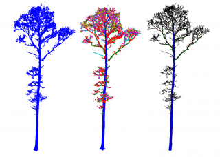
Our goal is to develop mathematical and computational methods that can process and analyse close-range laser scanner data from forests to tree models and other useful information about the trees. These include methods to isolate the individual trees from the data and more generally segmenting the data into different classes such as wood, leaf, and ground points. We develop methods to reconstruct quantitative structure models (QSMs) of the woody structure of trees. For this purpose we are continuously developing a method called TreeQSM, which is freely-available in GitHub. Currently major area of research is uncertainty quantification in QSM reconstruction and tree measurements. We also study methods to model and measure leaf cover as distributions over QSMs. Another area of study are methods for monitoring changes in the woody structure and leaf cover over time.
Our research team include Associate Professor Pasi Raumonen (pasi.raumonen@tuni.fi) and Doctoral Researchers Vincent Verhoeven, Pranjali Singh, and Pietari Mönkkönen. We are working in close collaboration with numerous institutes, both Finnish and international, with research fields varying from mathematical modelling to environmental research, forest sciences, and remote sensing. Our Finnish partner organisations include the Natural Resources Institute Finland (LUKE), University of Eastern Finland, and Tampere University of Applied Sciences. Our international partner organisations include Ghent University, University College London, UK Forestry Commission, Wageningen University & Research, and AMAP Lab.
The research has been funded by Academy of Finland (project: Centre of Excellence in Inverse Modelling and Imaging, 2018-2025) and FACCE ERA-GAS/Ministry of Agriculture and Forestry of Finland (project: Combining remote sensing and 3D forest modelling to improve the monitoring of GHG emissions in tropical forests, 2017-2021).